|
Caption |
|
|
Date |
May 2000 |
|
Camera |
Yashica T4 Super |
|
Lens |
Carl Zeiss 35mm T* |
|
Film |
Kodak E100 VS |
|
Tripod |
Handheld |
|
Field of View |
Approximately 120 degrees |
|
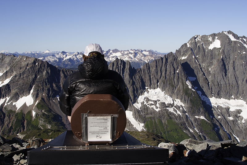
Description |
Silverstar is the very prominent peak just south of Route 20 on the east side of Washington Pass. This moderate mountaineering route starts on Route 20 a few hundred yards below the giant switchback in the road as you come down to the east from Washington Pass. A trail leads across Early Winter creek, up the north flanks of Silverstar to a flat area with good campsites at the base of an obvious line of weakness in Silverstar's impressive northern walls. The route ascends the obvious gulley on frozen snow, descends a bit, traverses over to the Silverstar Glacier, and ascends the gentle glacier to the saddle between North and South peaks, and then up the summit pyramid, a snow and ice covered third class scramble. The summit is a set of large blocks, and although I did touch the highest block, the thought of balancing on a square foot of rock over a 1000' drop made me not try to jump up on it! Exposures were made from just below the summit of Silverstar. I almost didn't think to make the panorama - I had already started down from the summit, helping some other climbers find the route. I was about to set up an anchor for a belay for some of the others when I realized the view would be a great opportunity for a panorama, so I went back up to where I could pan to get the most spectacular part of the view. |
|
Caption |
|
|
Date |
1 January 2001 |
|
Camera |
Nikon N80 |
|
Lens |
Nikon 28mm-105mm f3.5-f4.5 D, focal length unrecorded |
|
Film |
Fujichrome Provia 100F |
|
Tripod |
Gitzo G01 / Bogen 3262 |
|
Field of View |
Approximately 180 degrees |
|
Description |
On New Years Eve, the last day of 2000, Anne and I drove to Mt Baker ski area for a backcountry tour. We drove to the upper parking area, skinned up, and set out in a white out, with howling winds and chillingly low temperatures. After climbing up through the ski area onto the ridge around Artist Point, we could see nothing, and due to the flattish terrain, we had no idea where anything was. So we turned around, and because of the extremely limited to nonexistent visibility, actually used our GPS to find our track back at one point (not that we couldn't have done without the GPs, but it did decrease the stress level a bit). After a glorious New Years Eve in the little motel in Glacier, we returned to the same area on New Years Day. This time, the weather was spectacular, and we spent the whole day wandering around the area, taking pictures, and following the route up onto Ptarmigan Ridge on Mt Baker itself. What an incredible difference the weather does make! |
|
Caption |
|
|
Date |
November 2000 |
|
Camera |
Nikon N80 |
|
Lens |
Nikon 28mm-105mm f3.5-f4.5 D, focal length unrecorded |
|
Film |
Kodak E100 VS |
|
Tripod |
Handheld |
|
Field of View |
Approximately 90 degrees |
|
Description |
This panorama is quite bit different in terms of acquisition, in that I made it while flying solo in a Cessna 150 (N3198J) at 8000'. I flew around the area of Whitehorse and Three Fingers for a while, getting a really good feeling for the mountains' real shapes, and waiting for the sun to start to set. Finally the light became pretty good in terms of color and shadowing. I grabbed these exposures through the pilot's window, then headed for home at Boeing Field. Behind Whitehorse, Glacier Peak is very prominent. I bet you don't have a copy of this one in your photo archive! |
|
Caption |
|
|
Date |
May 2001 |
|
Camera |
Nikon N80 |
|
Lens |
Nikon 28mm-105mm f3.5-f4.5 D at 35mm |
|
Film |
Fuji NPC 160 negative film |
|
Tripod |
Handheld |
|
Field of View |
Approximately 100 degrees |
|
Description |
I made this panorama on a solo spring ski tour, towards the end of the spring ski season. The route starts from the Blue Lake parking lot and trailhead near Washington Pass, winds up through the forest above Blue Lake, and reaches the ridge comprising Liberty Bell, Early Winter Spires, and associated rock formations. The panorama was made from near the highpoint of the route, near South Early Winter Spire. One could ski back the same way, however a more exciting route is down the gulley next to South Early Winter Spire. After a brief downclimb over gravel and saturated dirt, this is a steep, narrow chute at the top, the snow consisting of avalanche debris covered with a sprinkling of rocks and gravel from the steep walls. I was pleased to see that not only I, but everyone else who had left ski tracks, had employed the traverse and kick-turn method in the upper reaches. The descent is over two thousand feet, and is truly wonderful terrain after the first bit of unpleasantness at the top. It deposits you right at the big hairpin turn on Route 20, just east of Washington Pass. Return to the car is by thumb. |
|
Caption |
|
|
Date |
June 2001 |
|
Camera |
Nikon N80 |
|
Lens |
Nikon 28mm-105mm f3.5-f4.5 D at 35mm |
|
Film |
Fujichrome Provia 100F |
|
Tripod |
Gitzo G01 / Bogen 3262 |
|
Field of View |
Approximately 200 degrees |
|
Description |
Anne and I backpacked in to the Ingalls Peaks area on a really fine Saturday in June. At the pass, we stopped for lunch and a panorama break. Although the weather was superb, the forecast for the next day was grim, so we hiked down from the pass to the campsites below the Ingalls Peaks in the panorama, pitched our tent, and headed up towards our objective, South Ingalls Peak (the left highpoint on the ridge to the left). The route starts with the trail to Lake Ingalls, and from there turns into a very easy class 2 talus hop, with maybe a couple of moves of class 3 depending upon your route. We arrived at the summit a half hour or so before sundown to find a lot of wind, and a mass of low clouds to the West just starting to billow up and over the mountain crests a couple of ridges to the West. After another panorama (not yet shown here), we made a beeline for camp, missed photographing an incredible alpenglow on Stuart due to being in the trees, and made it to our tent just as it got really dark. We congratulated ourselves for continuing on to the summit the next morning, since the Ingalls Peaks were hidden in cold swirling clouds which came down to within a couple of hundred feet of camp. Nevertheless, we made it out and back to the car with very few raindrops hitting us. |
|
Caption |
|
|
Date |
August 2001 |
|
Camera |
Nikon N80 |
|
Lens |
Nikon 28mm-105mm f3.5-f4.5 D at 35mm |
|
Film |
Fujichrome Provia 100F |
|
Tripod |
Gitzo G01 / Bogen 3262 |
|
Field of View |
Approximately 150 degrees |
|
Description |
Sahale has been on our peak list since we arrived in Seattle in 1995. On my first trip to the North Cascades quite a few years ago now, I had picked up a poster with a 360 degree panorama from the top of Sahale, and I've been just itching to make one for myself. We've made one attempt which ended at Cascade Pass in horizontal rain and 100' visibility, another which ended at Cascade Pass in horizontal snow and 100' visibility (we couldn't even see Sahale Arm on either of these trips), an attempt that ended in the parking lot at 6 AM in a pouring rainstorm which kept up all weekend, and another attempt that ended at Cascade Pass on a glorious July day, the first weekend of summer, when a snow cornice from some invisible height above came crashing down on us accompanied by bounding rocks, and Anne fell and broke her wrist trying to evade the rocks. But we did triumph this summer, as Lynn and Norbert Ensslin from New Mexico joined us and we finally bagged the summit, on a day that was unbelievably hot - I never wore more than shorts and tee shirt all day. It was great fun setting up the tripod on the summit, which consisted of some broken blocks of rock about the size of a coffee table, with interesting drops on a couple of sides. This a great trip, easy as far as the technical mountaineering aspects go, although a longish day at over 5,000' elevation gain. I leave it to you to judge whether the views are worth the effort!. |
|
Caption |
|
|
Date |
September 2001 |
|
Camera |
Nikon N80 |
|
Lens |
Nikon 45mm f2.8P, vertical format |
|
Film |
Fujichrome Provia 100F |
|
Tripod |
Gitzo G01 / Bogen 3262 |
|
Field of View |
Approximately 180 degrees |
|
Description |
Before the Trapper Mtn hike, with its views of the Pickets and Mt Triumph, I had considered the Green Mtn hike the best views of any all-trail hike I'd seen in the North Cascades. Anne and I hiked this with our friend Jonathan, and it was another of those incredible North Cascades summer days, with blue skies and warm weather. We spent an hour and a half on top. The panorama shows the Downey Creek drainage on the right of the green mountain peak in the foreground. This drainage is well known as one of the exits from the Ptarmigan Traverse. Once again, we were led to this superb view by "Don't Waste Your Time in the North Cascades", which rates it as a "Four Booter" (Premier) hike. |
|
Caption |
|
|
Date |
September 2001 |
|
Camera |
Nikon N80 |
|
Lens |
Nikon 28mm-105mm f3.5-f4.5 D at 105mm |
|
Film |
Kodak Supra 100 |
|
Tripod |
Gitzo G01 / Bogen 3262 |
|
Field of View |
Approximately 100 degrees |
|
Description |
This is perhaps the finest view obtainable by trail that I have seen in the North Cascades. The hike (and it is only a hike, there is no mountaineering required), is a "Four Booter" (Premier) hike in "Don't Waste Your Time in the North Cascades". One obtains the summit of Trapper Mtn to gaze down upon lakes, hanging valleys, moraines, glaciers, Mt Triumph less than two miles away, the entire Picket Range spread out across the Goodell Creek Valley, the Inspiration Traverse peaks south across the Skagit River valley. Bring plenty of film. We were blessed with an incredible day and spent over an hour on the summit. |
|
Caption |
|
|
Date |
September 2001 |
|
Camera |
Nikon N80 |
|
Lens |
Nikon 28mm-105mm f3.5-f4.5 D at 28mm |
|
Film |
Kodak Supra 100 |
|
Tripod |
Gitzo G01 / Bogen 3262 |
|
Field of View |
360 degrees |
|
Description |
Railroad Grade is a prominent ridge which cuts the southern side of Mt Baker between Easton and Deming Glaciers. Part lateral moraine, and part "cleaver", it's an incredibly uniform slope which takes you right up into the face of the glaciers on Baker, and just disappears into the ice. The panorama was made from that point, just a few dozen feet from the glacier. The hike (and again it is only a hike, there is no mountaineering required), is also a "Four Booter" (Premier) hike in "Don't Waste Your Time in the North Cascades". We returned to Mt Baker in June of 2002 for a warmup climb in preparation for a trip to Peru. For a photo album of that trip (and yes, at least a mini-panorama!), see our Mt Baker Trip Report. |
|
Caption |
|
|
Date |
November 2001 |
|
Camera |
Nikon N80 |
|
Lens |
Nikon 28mm-105mm f3.5-f4.5 D at 28mm, vertical format |
|
Film |
Kodak Supra 100 |
|
Tripod |
Gitzo G01 / Bogen 3262 |
|
Field of View |
Approximately 100 degrees |
|
Description |
This is the panorama that almost didn't happen. Anne and I woke up to a pretty miserable Sunday after a week of awful weather - it was the week the Times published the photo of salmon crossing the road in Skokomish. (They were all lined up and waiting for one of them to get across in front of a pickup truck.) Anne and I overcame the bad-weather blahs and drove to Snoqualmie Pass. We took a five minute depression nap before hiking up the Snow Lake trail on the windy, cloudy and chilly fall day to the ridge above the Lake. We then headed up towards Chair Peak through some old snow, looking for some view spots, and found this nice view of Chair Peak. The somewhat narrow panorama was constrained by making the images from a tree-covered ridge. This is a good example of why Seattle is a great base camp for mountaineering - this view is just over an hour from the car. |
|
Caption |
|
|
Date |
March 27, 2002 |
|
Camera |
Nikon N80 |
|
Lens |
Nikon 45mm f2.8P, vertical format |
|
Film |
Fujichrome Provia 100F |
|
Tripod |
Gitzo G01 / Bogen 3262 |
|
Field of View |
Approximately 100 degrees |
|
Description |
I made this panorama the day after six of us circumnavigated Crater Lake on the Rim Road via skis. Five of my friends from New Mexico and I started out on Sunday in nice weather following a significant snowfall. We started at Rim Village and proceeded clockwise around the lake, picking up our cars at Park Headquarters. (Two of our wives drove them down there from Rim Village.) We skied in and out of clouds the first day, with light snow accompanying the clouds. Camp was on the road just West of Lao Rock. Our second day started out bright and sunny, and the weather stayed that way for the rest of the trip. The second day, from 9 AM to 3:30 PM, ended at camp on the road a half mile Northeast of Cloudcap. The third, longest day went from 8:30 AM to almost 5:00 PM, but we left the Rim Road to follow Grayback Road in order to detour around dangerous avalanche terrain. This is a very nice (but strenuous) ski tour, requiring winter camping skills and the ability to ski with a full backpack, but it does not require a high level of skiing ability, since we were on roads the entire trip. The trip did cause me to forego packing an SLR and tripod due to weight! After a glorious evening at the Prospect Hotel, Prospect Tavern, and Prospect Cafe, my friends headed south to Ashland for the Shakespeare Festival, while I headed back up to Crater Lake with tripod and Nikon. This panorama was made just a few yards from the Rim Village parking lot, on top of the large snowbank. The snow-covered highpoints of the crater rim are The Watchman (left) and Hillman Peak (right); the black rocky promontory farther to the right is Lao Rock. Wizard Island lies to the left of Lao Rock. Crater Lake certainly did impress me with its spectacular beauty, and I look forward to a summer trip which would include a panorama from the top of Wizard Island's cinder cone. |
|
Caption |
|
|
Date |
May 27, 2002 |
|
Camera |
Canon Powershot G2 |
|
Lens |
Canon 7mm-21mm f2.0, focal length unrecorded |
|
Film |
Digital |
|
Tripod |
Handheld |
|
Field of View |
360 degrees |
|
Description |
This was the result of a great, late-spring backcountry ski trip to the North Cascades, with my wife Anne and myself. This was our third attempt to reach Cutthroat Pass starting from Rainy Pass. The first time we followed ski tracks up the wrong drainage, and then Anne's binding came loose. The second time, we were with friends and made to within a half mile of the pass, when Anne's professionally repaired binding came loose. This time, we made it. The trip is detailed in a trip report with additional photos. This is a truly spectacular trip, and we made a common variation by skiing over the pass, and down the Cutthroat Lake drainage, to exit on the road that follows Cutthroat Creek to hit Route 20 just a mile or two below the Switchback by Liberty Bell. This is the first panorama with a digital camera, which I am pleased to say survived the trip and produced some pretty nice photos. |
|
Caption |
|
|
Date |
August 11, 2002 |
|
Camera |
Canon Powershot G2 |
|
Lens |
Canon 7mm-21mm f2.0, focal length unrecorded |
|
Film |
Digital |
|
Tripod |
Handheld |
|
Field of View |
180 degrees |
|
Description |
Once again Anne and I scored by checking out a "Four Booter" from "Don't Waste Your Time in the North Cascades". This is an incredible hike, with the views starting to appear after only an hour of walking, and building to a sudden and almighty crescendo as you reach the summit of Hidden Lake Peaks (the summit in the left foreground in the panorama). That view (from the summit) has its own panorama, a work in progress. This panorama captures both the high point of Hidden Lake Peaks (on the left), and the crag on which is perched the old Forest Service lookout built in the 1930's (on the right). Two weeks earlier, I had come up to this same peak with overnight gear, but spent the entire weekend in the clouds. On that trip, I spent the night in the lookout, which is a cozy historical building lovingly maintained by the Friends of Hidden Lake Lookout. However, there were no views (beyond about two hundred feet). So this weekend, Anne and I came back on a day trip. If you have only one day to spend in North Cascades National Park, I think I'd recommend this hike, as it really shows you the jewels of the North Cascades. Starting from the left summit of Hidden Lake Peaks, you have the pointed pyramidal Forbidden Peak, one of the Fifty Classic Climbs of North America. Next to the right is the rounded summit of Boston Peak, with the little pyramid of Sahale to its right. Continuing right, there is the notch of Cascade Pass, but it's obscured by the left flank of the massive Johannesburg Mountain. The Ptarmigan Traverse, a famous high-country route that follows the terrain in the right half of the panorama, starts at Cascade Pass. Depending on your endurance, it ends at one of several places more or less in front of Glacier Peak, visible in the background. In addition to all this, when you reach the summit you will see Eldorado Peak before you , with much of the Inspiration Traverse visible, as well as the Southern Pickets, Mt Shuksan, and Mt Baker. |
|
Caption |
|
|
Date |
September 11, 2002 |
|
Camera |
Canon Powershot G2 |
|
Lens |
Canon 7mm-21mm f2.0, focal length unrecorded |
|
Film |
Digital |
|
Tripod |
Gitzo G01 / Bogen 3262 / Novoflex Universal Panorama Plate |
|
Field of View |
160 degrees |
|
Description |
Sometimes it's difficult to identify one's motivations for a hike into the mountains. This image was made on September 11, the first anniversary of the attacks on the World Trade Center and the Pentagon. I worked on this day until noon, then headed up to the North Cascades to repeat the hike up Hidden Lake Peaks that resulted in the above panorama. This time, I wanted to be on the summit at sundown, and I wanted to climb up the north ridge, instead of hiking the normal trail. I also committed to a solo climb, as Anne had to keep her nose to the grindstone. The north ridge is a truly wonderful route up Hidden Lake Peaks, as once you make the notch in the ridge (Sibley Pass), you are on beautiful white rock virtually the entire way. There is never any technical difficulty, but you are always scrambling on gorgeous rock and you are always presented with route choices that make the way a little easier or a little harder. I reached the summit in plenty of time to photograph the sunset, and pulled out some cold pizza while I set up the tripod, my Nikon film camera, and my Canon digital camera. It was unbelievably clear and warm for 7000' in September - the temperatures were probably in the 60's. The sunset was indeed wonderful, and I ran several rolls of film through the Nikon and filled half a gigabyte of memory with the Canon. This panorama is one of several, made in changing light, with totally different appearances. Somewhere around sunset, I paused and thought about all the people in New York and Washington that will never get a chance to experience the incredible beauty I was experiencing, and there was nothing I could do to help them. But if you find any joy or beauty in this image, send it as a prayer to the spirits of those people. |
|
Caption |
|
|
Date |
22 September 2002 |
|
Camera |
Canon Powershot G2 |
|
Lens |
Canon 7mm-21mm f2.0 at 7mm, vertical format |
|
Film |
Digital |
|
Tripod |
Gitzo G01 / Bogen 3262 / Novoflex Universal Panorama Plate |
|
Field of View |
360 degrees |
|
Description |
This was another solo hike. I headed out a bit late, but got up to Easy Pass around 3 PM. From there, I climbed the grassy hill to the North and hung out for a couple of hours on the next high point. I was just south of Pt 7690, on a little rise in the ridge at 7300'. The weather was gorgeous, and I did lots of panoramas in between gawking at the views and identifying peaks. I waited until just after the sun disappeared, then started down. It turns out this was a bad move, because after I got back to the pass, the sky lit up in the most incredible flaming pink! (There was a forest fire producing a lot of smoke to the northeast.) I made it back to the car in the dark around 9 PM. |
|
Caption |
|
|
Date |
1 June 2003 |
|
Camera |
Canon Powershot G2 |
|
Lens |
Canon 7mm-21mm f2.0 at 7mm, vertical format |
|
Film |
Digital |
|
Tripod |
Handheld |
|
Field of View |
Approximately 180 degrees |
|
Description |
This image was made on the Memorial Day weekend. We had intended to do a three-day ski backpack to Cylone Lake and Snowking Peak in the North Cascades, starting from the Cascade River Road area. On Saturday, we found the road blocked about two miles and 600' below where we had anticipated, making for a longer day ahead. Then, we found the beginning of the trail up the ridge very brushy and unpleasant with skis on the pack and plastic ski boots on the feet. But we forged on, until the clouds dropped to the valley, it became dark in the forest in late afternoon, and it started to rain. After several wrenching, soul-searching discussions we decided the weather looked worse than forecast and did not look like it would improve, so we turned around and hiked right back down the full 2000' we had just ascended! We stayed the night in a cabin in Marblemount. The next day, after a great breakfast at Howie's in Marblemount, we got to work, driving to the Thornton Lake Trailhead and packing in without the skis, in moderately cloudy weather. We hit full snowpack at 4000', and made the ridge looking down onto Thornton Lake in the late afternoon, so we could get the view from the ridge before heading down to the campsites at the lakes. This panorama was made at that time. The next morning, we left camp and bagged Trapper Peak, a route almost entirely on snow and with a large number of cornices to spice it up. All this time, the weather was mostly cloudy, with Mt Triumph's summit never appearing, and the mountains towards Snowking completely socked in. As we broke camp to descend to the car, the weather began to clear, and by the time we reached the car the sky was blue over the Snowking area. Of course! |
|
Caption |
|
|
Date |
27 June 2003 |
|
Camera |
Nikon N80 |
|
Lens |
Nikon 105mm f2.8 Micro Nikkor |
|
Film |
Kodak Supra 100 |
|
Tripod |
Gitzo G01 / Stroboframe ballhead / Novoflex Universal Panorama Plate |
|
Field of View |
Approximately 100 degrees |
|
Description |
The weather was forecast to be clear and warm for Friday and Saturday, then turning to clouds and rain on Sunday. So I arranged to work Sunday and took off Friday morning for Ruth Mountain, right next to Mt Shuksan, for another solo outing. Ruth is a technically easy snow slog, although a lot of work at 6 miles and 4000' to the summit from the car. I took a full backpack as well as photo gear, as I intended to camp on the summit. The weather was just as forecast, one of those summer Cascades weekends that are indescribably delicious, and help to get you through the winters. I followed an hour behind a solo skier to the top, but I was alone on the summit. I didn't even bother to put up my tent, as the weather was clear and the temperature never dipped down past 45 at night, I'd guess. The views from up there, at sunset and sunrise, are among the most fabulous I've experienced, with Mt. Shuksan so close you can see and hear the ice avalanches roar down into Nooksak Cirque all evening. This panorama of the Northern Pickets was done just before the sun slid below the horizon on Friday evening. Whatcom, Challenger, and Fury are the promiment peaks left to right. |
|
Caption |
|
|
Date |
19 July 2003 |
|
Camera |
Canon G2 |
|
Lens |
Canon 7mm-21mm f2.0 at 21mm |
|
Film |
Digital |
|
Tripod |
Gitzo G01 / Stroboframe ballhead / Novoflex Universal Panorama Plate |
|
Field of View |
Approximately 100 degrees |
|
Description |
We seem to be enjoying a fabulous summer in the Cascades, so we wanted to take advantage of the nice weather and do something a little unusual. The plan we came up with was to climb Mt Daniel, a 7,900' peak in the Cascades not too far from Mt Stuart, but to backpack up all the way to the summit plateau to spend the night instead of camping at the usual spot, Peggy's Pond. With such great weather forecast (clear, 15,000' freezing level), it seemed a shame to hang out down in the trees for the evening, even if Peggy's Pond is a very beautiful spot with Cathedral Rock jutting up right out of the water. All went well, we climbed up moderate snow slopes until we intersected the southeast ridge at around 7,300'. However, one of the party was on his first real snow climb, and felt justifiably uncomfortable looking at the final traverse on snow above some rather prominent cliffs, with evening approaching and hauling a heavy pack. So we decided to leave the snow and climb the vague trail on the loose southeast ridge. We pushed on to 7,500' looking for a flat spot to camp, but our loads were telling on us and we didn't have the energy to push over the final steep and loose sections. So we had to backtrack a few hundred feet on the ridge to get a nice site. We made camp in time for the glorious sunset colors. Moderate winds gusted our tents all night, and we awoke to a cloud deck covering the East Peak of Daniel, which proceeded to lower. Being fair weather folk, we opted for a descent instead of wandering around in the clouds. Of course, by the time we were back down to the trail, the sky had cleared and it was a glorious sunny day again, as usual! |
|
Caption |
|
|
Date |
16 August 2003 |
|
Camera |
Canon G2 |
|
Lens |
Canon 7mm-21mm f2.0 at 7mm |
|
Film |
Digital |
|
Tripod |
Handheld |
|
Field of View |
Approximately 150 degrees |
|
Description |
Our friends the Walters came up from New Mexico to add Glacier Peak to their list of Washington volcano summits. Anne and I had climbed Glacier several years ago, on the July 4th weekend after a record breaking snow year, so we served as "guides". We set aside three days for the trip, as it is about 10 miles and 3500' in to camp, and it's about a 5000' summit day, so hiking back out the same day as summitting makes for a very long and unpleasant day. So off we went on Friday morning heading in to camp. The weather had been warm and clear under the influence of a high pressure system for days, however the forecast was for a low to pass through on Friday evening, clearing Saturday afternoon. Sure enough, a couple of hours after we reached our camp at Boulder Basin, it was as if a switch had been thrown, and the clouds just appeared all around us, lowered, and started to drizzle on us. It was drizzling and socked in at camp at our 4 AM wakeup, so we decided to wait. It was also socked in and drizzling at 6 AM and 8 AM, but we finally got up and had breakfast in the drizzle. Two other parties left without making a summit attempt. However, we had faith in the National Weather Service, as they had predicted the start of the bad weather exactly, and we expected Saturday afternoon to be clear. So, at about half past noon, we headed off for the summit in the fog. As we reached the Sitkum Glacier, we could see the summit occasionally through clearings in the clouds, and as we climbed the glacier the clouds broke up more and lowered. We reached the summit pyramid area around 6 PM, and made an unfortunate choice to climb the little ice gulley mentioned in the guide book, instead of crossing it and following the trail. The gulley topped out between overhanging rocks, only about ten feet below the true summit, with the route to the summit a 150-foot wide, 40-degree ice slope. I led across but decided not to bring the party across, so we headed back down. This panorama was taken near the saddle between Sitkum Spire and the pumice slope leading to the summit pyramid. Mt Rainier is visible in the left part of the horizon, Mt Baker to the right of Sitkum Spire. The descent was straightforward, and we reached the moraine trail just as the darkness required our headlamps. We followed the trail down and reached camp about 11:30 PM. Sunday, we slept in and hiked out in glorious summer weather again. We were very impressed with the complete accuracy of the National Weather Service forecast! |
|
Caption |
|
|
Date |
21 September 2003 |
|
Camera |
Canon Digital Rebel |
|
Lens |
Canon 28mm-105mm f3.5-f4.5 EFS II at 28mm |
|
Film |
Digital |
|
Tripod |
Handheld |
|
Field of View |
360 degrees |
|
Description |
This is the third panorama from the top of Hidden Lake Peaks. One previous panorama is from the saddle between the true summit and the lookout, one is from the true summit, and now we have this panorama, taken from the top of the rock protruding above the lookout. I just love this hike and the views from this peak, as you might be able to tell! For this hike, Anne and I ascended with a couple of friends, Dave Cowan and Steve Denison. As an added bonus, just as we were leaving the parking lot we ran into another old friend and his son, Jeff and Alex Howbert. So we all had a great time sunning ourselves on the summit and having a nice lunch, while reviewing our maps and refreshing our memories of the surrounding peaks names. In case I haven't said it before, this is a great hike! |
|
Caption |
|
|
Date |
21 September 2003 |
|
Camera |
Canon Digital Rebel |
|
Lens |
Canon 70mm-200mm f4.0 L at 200 |
|
Film |
Digital |
|
Tripod |
Handheld |
|
Field of View |
Approximately 25 degrees |
|
Description |
Forgive me, this is the fourth panorama from the top of Hidden Lake Peaks! I just can't help it, the views from there are spectacular. This panorama was made on the same hike as the panorama from the rock above the Hidden Lake Peaks lookout. We were just starting to leave the lookout area (prematurely, as far as the photographer in me was concerned!), and I stopped to whip out the Canon 70mm-200mm lens and make some closeups of Forbidden Peak and Sahale Mountain. If you've ever hiked the Cascade Pass area to get a glimpse of Forbidden (one of the 50 Classic Climbs of North America), well this is the view you don't get from Cascade Pass! |
|
Caption |
|
|
Date |
22 March 2004 |
|
Camera |
Canon Digital Rebel |
|
Lens |
Canon 70mm-200mm f4.0 L at 200mm |
|
Film |
Digital |
|
Tripod |
Gitzo G01 / Gitzo G1177M Ballhead / Novoflex Universal Panorama Plate |
|
Field of View |
Approximately 100 degrees |
|
Description |
I'd skied the Mission Ridge downhill area twice before, and although the locals had raved about the views from the top, all I had seen were eye-level blowing clouds. So this time I was pleased to see the morning start off with bright, sunny blue skies over Mission Ridge. The bad news was, early morning spring conditions for skiing, also known as 'ice' out west, although by Vermont standards it was just 'hardpack' since you could not actually see the rocks and dirt through the skiing surface. At any rate, I did a number of runs on my alpine ski gear and built character by going off-piste and down a chute or two. But after lunch, I hauled out the backcountry ski gear, rode the lift to the top, skinned up, and headed over to the high point of Mission Ridge, aka Mission Peak. Meanwhile, the weather had decided it was still winter after all, and a leaden and amazingly uniform grey cloud layer appeared over everything. I skied up to a spot with some bare rocks and relics of some old cable car operations or something, set up the tripod, and made this panorama. The sky was imparting such an incredibly grey look to everything that I have converted this image to black and white, although the original is in color. |
|
Caption |
|
|
Date |
4 April 2004 |
|
Camera |
Canon Digital Rebel |
|
Lens |
Canon 28mm-105mm f3.5-f4.5 EFS II at 28mm |
|
Film |
Digital |
|
Tripod |
Handheld |
|
Field of View |
360 degrees |
|
Description |
If you like backcounty skiing, and you like Mt Rainer, then you will definitely like the ski tour from which this panorama resulted. And if you don't like those two things, what are you doing in Washington? The tour starts at Paradise. You ski down the road to a switchback below Mazama Ridge, and then skin up the side of the ridge to the crest. From there, you follow the ridge crest until you reach the rolling hills area from which the summertime Paradise Glacier Trail begins. Follow this general line of attack until you reach the base of Cowlitz Rock, and then skin or boot up to the summit of the rock. We have done this tour a number of times, and have found the snow to be usually pretty good from the summit of Cowlitz Rock down to where you start to descend the flank of Mazama Ridge. On this trip, we skied up to tree line on Mazama Ridge and setup up camp in the last little clump of three or four trees. The site and the views were incredible, and the full moon on Rainier was unbelievable. The next morning, we sat around drinking coffee for quite some time until the frozen spring snow softened up a bit, and then made our way up to Cowlitz Rock, from which this panorama was made. The skiing down was extremely good on the whole, and it was a really lovely spring ski tour. |
|
Caption |
|
|
Date |
17 July 2005 |
|
Camera |
Canon Digital Rebel XT |
|
Lens |
Canon EF 28-105mm f3.5-4.5 II at 28mm |
|
Film |
Digital |
|
Tripod |
Gitzo G01 / Gitzo G1177M ballhead / Novoflex Universal Panorama Plate |
|
Field of View |
360+ degrees |
|
Description |
A previous panorama from the top of Sahale is available on this Web site. However, it is not a full 360-degree panorama, and it left me with an unfulfilled feeling. After all, my inspiration for these panoramas was the 360-degree poster of the North Cascades I saw in the Marblemount Ranger Station many years ago, and still available. So, I returned this year intending to complete the mission. I made a three-day solo trip up Sahale, stopping at many places along the way for photos. I did find a mostly 3rd class route up the summit block of Sahale, from which this complete 360-degree panorama was made. I am so thankful I took three days to climb what most people consider a day trip. I had the time to see so many more nooks and crannies of the Cascades than do most climbers. And, I got the use the most spectacular morning meditation spot in the Cascades! |
|
Caption |
|
|
Date |
9 September 2005 |
|
Camera |
Canon Digital Rebel XT |
|
Lens |
Canon EF-S 10-22mm f3.5-4.5 at 22mm |
|
Film |
Digital |
|
Tripod |
Gitzo G1127 Mk2 / Gitzo G1177M ballhead / Novoflex Universal Panorama Plate |
|
Field of View |
Approximately 160 degrees |
|
Description |
A previous image in this collection showed Crater Lake, but from a very limited perspective on the rim. This image shows the entire lake, along with its setting, from Mt McLoughlin in the south to Mt Thielsen in the north. On this trip, we drove to Crater Lake and spent the night in Chateau Toyota in the lodge parking lot. The next day, we drove around the rim, stopping for views as appropriate. The physical part of the tour was a hike up Mt Scott, the high point of the park. It's a very nice, easy hike with an excellent trail, reasonable elevation gain, and a great vantage point on top. This panorama was made from the false summit a few hundred yards south of the lookout building. |
|
Caption |
|
|
Date |
20 June 2005 |
|
Camera |
Canon Digital Rebel |
|
Lens |
Canon 70mm-200mm f4 L at 200mm |
|
Film |
Digital |
|
Tripod |
Gitzo G01 / Gitzo G1177M ballhead |
|
Field of View |
Approximately 25 degrees |
|
Description |
This image arose from one of those "gotta get outta the house and make some photos" moments. Having fond memories of watching the sunset from the top of The Haystack on Mt Si, I packed up the tripod and full lens kit and headed on up, aiming to get to the top just before sunset. It was a glorious sunset, not only colorful but pretty clear also, and you could see from Baker to Rainier. As the sun set in the West, the colors to the North took on spectacular shades of blue, and Mt Baker was just poking out above the Cascades foothills. The only thing that could have made the moment more complete was to see the mountain goats perched on rock outcrops watching the sunset, that I had seen on a previous sunset climb of Mt Si. |
|
Caption |
|
|
Date |
19 October 2003 |
|
Camera |
Canon Digital Rebel |
|
Lens |
Canon EF-S 18-55mm f3.5-5.6 at 18mm |
|
Film |
Digital |
|
Tripod |
Handheld |
|
Field of View |
Approximately 120 degrees |
|
Description |
Ah, October in the Cascades! We nurture still a hope of dry weather and a glimpse of views from a summit. The reality is usually much uglier. However, on the whole I can't complain about this day, it was dry, and it did afford some views. Also, I had driven up the logging road that in the winter is the "Second Kendall Knob" approach from Gold Creek, so I saved a lot of viewless hiking in the trees. From the parking spot, it is a very short bushwhack to the Pacific Crest Trail and right on over to Kendall Peak. Choosing a looser and less pleasant gulley than must be possible, I summitted in short order and snapped a few frames with the wind in my teeth. It was actually pretty spectacular to see the wind blowing the clouds off the western faces of the mountains, leaving a boiling mass of clouds on the leeward side. Snoqaulmie Pass is the low point near the center of the panorama; Snoqaulmie Mtn and Red Mtn are the peaks on the right. |
|
Caption |
|
|
Date |
12 August 2006 |
|
Camera |
Canon Powershot S70 |
|
Lens |
Canon 5.8-20.7mm f2.8-5.3 at 5.8mm |
|
Film |
Digital |
|
Tripod |
Handheld |
|
Field of View |
Approximately 130 degrees |
|
Description |
Three friends and I attempted the North Cascade's Ptarmigan Traverse in early August, betting on this time of year to give us the best shot at good weather. We planned on five travel days and one rest or bad weather day, going in at Johnannesburg trailhead and coming out Downey Creek. The first day, from Johannesburg trailhead to Cascade Pass, up the Cache Glacier to Cache Col, and down to Kool Aid Lake, was beautiful weather. Alarmingly, we saw four bears at one time from our camp site, but they kept their distance. The next day dawned unfortunately foggy, drizzly, and misty. However, we departed anyway for the unpleasant Red Ledges, the traverse to the Middle Cascade Glacier, the ascent of the glacier in 50-100 foot visibility, and the descent from Spider-Formidable Col to Yang Yang Lakes. The next day dawned clear, but with ominous clouds boiling over the ridge crest to the West. We climbed to Le Conte Pass, where within minutes the clouds descended to ground level and rain began. So we pitched the tents and lay in the rain for eighteen hours straight. The next morning, the rain stopped at 6 AM but the fog limited visibility to less than 100 feet, and we could not continue on this less well marked part of the trail. With two days lost, and an unknown forecast, we had no alternative but to travel back, so we spent our last night at Kool Aid Lake again. The final morning dawned clear above, but with a solid marine layer filling the valleys, the quintessential Cascades view. This panorama was taken from our camp at Kool Aid Lake, and shows Mt Formidable on the left, and Johnannesburg Mtn and Mixup Peak on the right. Although we did not reach our goal, we had a wonderful time in a spectacular mountain environment with good friends - a trip we'll long remember. |
|
Caption |
|
|
Date |
27 August 2006 |
|
Camera |
Canon Digital Rebel XT |
|
Lens |
Canon EF-S 17-55mm f2.8 at 17mm |
|
Film |
Digital |
|
Tripod |
Handheld |
|
Field of View |
Approximately 160 degrees |
|
Description |
On our Ptarmigan Traverse trip of early August, we had spent some time taking pictures on the ridgeline above Cache Col on our way out to Cascade Pass. I noticed a small tent site, with a low windbreak of rocks, and thought it would make a truly spectacular place to camp. And it was just far enough out of the Park to make a legal camp site. It would require absolutely perfect summer weather to make it enjoyable, but the forecast showed the weekend of August 26-27 to be one such - "sunny" days, "clear" nights, no chance of precipitation, temperatures in the passes approaching 80 Fahrenheit. We could not waste such an opportunity, so Anne and I retraced (for the third time in three weeks for me) the first part of the Ptarmigan Traverse - Johannesburg Trailhead to Cascade Pass, up over the gulley-scored traverse to the Cache Glacier, and up the glacier to Cache Col. The camp was every bit as spectacular as you could imagine, with the sheer cliffs to the north dropping hundreds of feet to the Cache Glacier just a few yards from our tent. We could see a 360 panorama of the Cascade Pass peaks, and the Hurry Up, Spider, and Formidable peaks as well. Snow King filled the Western horizon. Rockfall from the neighboring ridges popped and crashed periodically. The weather was warm, we lounged around and gawked at the views, and we stuffed ourselves with macaroni and cheese with tuna and real New Mexico Hatch green chili. The stars at night burned brightly in the sky and an early evening wind died down by midnight. At sunrise, the sky to the west turned pink and I made this panorama. |
|
Caption |
|
|
Date |
9 September 2006 |
|
Camera |
Canon Digital Rebel XT |
|
Lens |
Canon EF-S 10-22mm f3.5-4.5 at 22mm |
|
Film |
Digital |
|
Tripod |
Gitzo G1127 Mk2 / Gitzo G1177M ballhead / Novoflex Universal Panorama Plate |
|
Field of View |
360 degree loop |
|
Description |
An early September weekend found me looking for a solo overnighter destination in the mountains. Unfortunately, the weather was not looking good for Saturday, but I loaded up the car and headed down to Mt Rainer. Amazingly, I found there was a free campsite at the popular Snow Lake, in the Tatoosh Range just south of Mt Rainier, so I grabbed a permit for the site. By the time I left the car at 4 PM, the skies were only mostly cloudy, and it was dry. The short hike got me to the campsites, where Site 1, on a point above the lake with expansive views all around, was taken. Site 2 was in the trees, but with the lake only twenty feet away and visible between the trunks. It was a great site, and Snow Lake was gorgeous, with Unicorn Peak shooting up on one side and a high ridge line on the other. The next morning dawned crystal clear. I decided to attempt Unicorn Peak, however I did not carry an ice axe or poles and found the normal route blocked by a snow traverse, which I therefore declined on general principles. The options open to me took me up third-class, very loose and ugly, not to mention dirty rock, so I backed off and saved it for another day. However, a short traverse across a moraine took me to the ridgeline that terminates in a high point between Unicorn and Castle, which I took. This panorama was made from there, where I spent two wonderful hours on the lovely little summit before returning to Snow Lake. I would have to say that the amount of loose talus available on this route should satisfy even the most ardent devotee of scree and mobile rock fragments! |
|
Caption |
|
|
Date |
24 September 2006 |
|
Camera |
Canon Digital Rebel XT |
|
Lens |
Canon EF 28-105mm f3.5-4.5 II at 35mm |
|
Film |
Digital |
|
Tripod |
Gitzo G1127 Mk2 / Gitzo G1177M ballhead / Novoflex Universal Panorama Plate |
|
Field of View |
360 degree loop |
|
Description |
It looks like September is Volcano Month at Cascades Panoramas! The weekend of September 23-24 was an incredible surprise - weather like mid-summer, after a week of weather so miserable we thought winter had already arrived. But on the 24th, we set out to do one of the few "four-booter" (Premier) hikes in the "Don't Waste Your Time in the North Cascades" book that we had not done. On the northern slopes of Mt Baker, the "Skyline Divide" hike delivers perhaps the best "bang for your buck" hike we have seen. After only an hour of hiking a very nice trail in lovely forest, we broke out onto the Skyline Divide ridge to see fabulous views of Mt Baker, Mt Shuksan, and the other peaks visible from this vantage near the Canadian border. One could stop here and hang out sunning oneself and looking at the views in perfect contentment. We hiked on another hour or so to find the perfect panorama and lunch site, from which this panorama was made. |
|
Caption |
|
|
Date |
28 September 2006 |
|
Camera |
Canon Digital Rebel XT |
|
Lens |
Canon EF 17-40mm f4 L at 40mm |
|
Film |
Digital |
|
Tripod |
Gitzo G1127 Mk2 / Gitzo G1177M ballhead / Novoflex Universal Panorama Plate |
|
Field of View |
Approximately 150 degrees |
|
Description |
This panorama is something of an exception to the usual type of panorama on this site - I just drove my car up to the spot and set up the tripod. No hiking or climbing was required! The hardest thing was finding a space in the park on Queen Anne Hill that was not already occupied by a photographer with tripod, massive lens, and equally massive gear kit - not to mention the (seeming) hundreds of other folk with point-and-shoot cameras. But still, it is a panorama with a Cascades mountain. |
|
Caption |
|
|
Date |
11 October 2006 |
|
Camera |
Canon Digital Rebel XT |
|
Lens |
Canon EF-S 10-22mm f3.5-4.5 at 22mm |
|
Film |
Digital |
|
Tripod |
Gitzo G1127 Mk2 / Gitzo G1177M ballhead / Novoflex Universal Panorama Plate |
|
Field of View |
360 degree loop |
|
Description |
So there we were, halfway into October and the work week beginning gloriously warm and sunny; it was incredible that we were blessed with weather this good, this late in the year. And the forecast was for miserable muck on the weekend. What would you do? I was fortunately able to swap a work day so I could head into the mountains on Wednesday and work on Saturday. I drove up to the Rainy Pass trailhead early Wednesday in the Carrera 4 in "pretty good time" (don't ask, that's for some other Web site). Having never taken the paved trail to Rainy Lake, I checked that out and was suitably impressed by the beauty. Then, it was back to the Heather Pass/Maple Pass trailhead which was shorter than I remembered. Heather Pass was incredibly glorious, with yellow and gold larches, blue sky, and Black Peak figuring prominently in the views. Carrying on, I made this panorama at one of the largish flat areas at Maple Pass. I did continue on to the ridge to the east, above the trail as it dropped down to Rainy Lake, and spent a few hours hanging out and doing some evening panos. Then it was back to the car after dark, with one of my favorite trail companions - Yo Yo Ma playing Bach's suites for unaccompanied cello. And the best part - I really did get a lot of work done on Saturday ;-) |
|
Caption |
|
|
Date |
11 October 2006 |
|
Camera |
Canon Digital Rebel XT |
|
Lens |
Canon EF 17-40mm f4 L at 20mm |
|
Film |
Digital |
|
Tripod |
Gitzo G1127 Mk2 / Gitzo G1177M ballhead / Novoflex Universal Panorama Plate |
|
Field of View |
Approximately 160 degrees |
|
Description |
This is one of the evening panos I made from the ridge above Maple Pass, that I described in the Maple Pass 360 entry above. |
|
Caption |
|
|
Date |
22 October 2006 |
|
Camera |
Canon Digital Rebel XT |
|
Lens |
Canon EF 17-40mm f4 L at 17mm |
|
Film |
Digital |
|
Tripod |
Gitzo G1127 Mk2 / Gitzo G1177M ballhead / Novoflex Universal Panorama Plate |
|
Field of View |
360 degree loop |
|
Description |
Well I guess I'm nothing if not a creature of habit. Here I am again on Skyline Divide, this time with a tent, stove, and almost a gallon of water (you can't scrimp on that morning coffee). I'm also enjoying a gloriously clear Saturday and Sunday, although it's cool enough that the formerly wet trail has been turned into a long bed of fascinating giant ice crystals pushing up into the air. This panorama was made at my camp at the 6533' knob before dropping down to Chowder Ridge. The knob is prominently visible from much of the lower part of the ridge. It is a wildly spectacular place to camp, although you really want nice weather - I had visions of being awakened at 2AM with a 30 mph wind howling through camp. Fortunately, the night was absolutely dead calm and the stars were incredible. I met several groups of people who said they had been thinking what a great place to camp it would be, and they were right! |
|
Caption |
|
|
Date |
13 August 2005 |
|
Camera |
Canon Digital Rebel XT |
|
Lens |
Canon EF 28-105mm f3.5-4.5 II at 105mm |
|
Film |
Digital |
|
Tripod |
Gitzo G01 / Gitzo G1177M ballhead / Novoflex Universal Panorama Plate |
|
Field of View |
Approximately 65 degrees |
|
Description |
Anne and I climbed Ruth Mtn one fine August weekend. We arrived at camp on the grassy north ridge just below Ruth and set up camp. It was a gorgeous spot, with Ruth towering just above us, Shuksan off to the west, and the Pickets off to the east. We headed for the summit to get photos in the evening light. There were lots of crevasses on the glacier, in contrast to a trip I had done once earlier in the year when the glacier was completely filled in. This panorama was made on top, with afternoon lighting warmed a little bit by the sun as it just started to get low. It is a telephoto panorama, so it doesn't span many degrees of horizon, but it shows lots of detail in the Northern and Southern Pickets. Note: Starting with this panorama, I will no longer be providing links to the Hot Media viewers for the panoramas. Only JPEG images will be provided. |
|
Caption |
|
|
Date |
13 August 2005 |
|
Camera |
Canon Digital Rebel XT |
|
Lens |
Canon EF 28-105mm f3.5-4.5 II at 105mm |
|
Film |
Digital |
|
Tripod |
Gitzo G01 / Gitzo G1177M ballhead / Novoflex Universal Panorama Plate |
|
Field of View |
Approximately 55 degrees |
|
Description |
This panorama was made on the same trip to Mt Ruth as the above panorama. These images were made on the way down, after the evening colors intensified and warmed colors. It is also a telephoto panorama, and once again shows good detail and colors in the area around Whatcom Pass. |
|
Caption |
|
|
Date |
2 June 2007 |
|
Camera |
Canon Powershot S70 |
|
Lens |
Canon 5.8-20.7mm f2.8-5.3 at 5.8mm |
|
Film |
Digital |
|
Tripod |
Handheld |
|
Field of View |
360 degrees |
|
Description |
Well this panorama is something of a departure from the usual Cascades Panoramas, isn't it? But I can say that it is indeed a Cascades Panorama because, even though it may not be visible in the online images, Mt Baker is visible in the image. It's on the horizon just above the channel leading into the leftmost cove. Anyway, Sucia is a beautiful place. In the San Juan Islands, and one of the most popular of the Washington State Marine Parks, it is a large island with several anchorages, lots of interesting trails, cool little coves, and many very interesting rock formations. You can charter a very lovely 32' sailboat and see Sucia Island for yourself. See the Web site for S/V Andiamo (a 32' Beneteau/Moorings 32.2). |
|
Caption |
|
|
Date |
24 August 2007 |
|
Camera |
Canon Digital Rebel XT |
|
Lens |
Canon EF 17-40mm f4 L at 24mm |
|
Film |
Digital |
|
Tripod |
Handheld |
|
Field of View |
Approximately 200 degrees |
|
Description |
The summer of 2007 has been (for us at least) a season of cloudy weekends and sunny workweeks. Fortunately, I do have some flexibility in my working times at this point, and this panorama was made on a Thursday/Friday "weekend" after postponing the weekend days-off from the previous week. The two days were absolutely gorgeous, and we decided to explore some terrain near home - Snoqualmie Pass. The Pacific Crest Trail runs through the Pass, and we took it north, past Kendall Peak, over the famous Kendall Katwalk, and on over to Ridge Lake, a lovely lake with great views of the Gold Creek valley. We found a terrific tent site, just on the edge of the talus field tumbling down from the trail, with warm sunset light on the talus for evening cooking, and eastern exposure to give us sunlight on the tent the next morning. Hanging around camp the next morning, I finally took off for Alaska Mtn, less than an hour up the trail. After checking out some false summits and the true one, I made this panorama from the summit ridge on the east of the mountain. There were fabulous views of Chikamin, Alta, Rainier, and Kendall. We hiked out later that day, lingering in the warm sunlight an great views, postponing our return to the traffic noise of the I-90 corridor. |
|
Caption |
|
|
Date |
13 September 2007 |
|
Camera |
Canon Digital Rebel XT |
|
Lens |
Canon EF 17-40mm f4 L at 17mm |
|
Film |
Digital |
|
Tripod |
Gitzo G01 / Gitzo G1177M ballhead / Novoflex Universal Panorama Plate |
|
Field of View |
360 degrees |
|
Description |
Yet another forecast loomed for a spell of good weather during the workweek and clouds/fog/showers on the weekend, so this time we headed up to North Cascades National Park on a Thursday. We were impressed with the road repairs on the Cascade River Road, but wondered how long the river would tolerate a gravel road traveling along its new bed. The weather was gorgeous as we pulled into the trailhead for Cascade Pass, bright and sunny and not too hot. We stopped for a brief break at Cascade Pass, then headed up Sahale Arm. We are always overwhelmed by the beauty of the area, and the short climb up the steep and sometimes loose trail to the crest of the Arm is well worth the extra effort. The 360-degree views and the view down to Doubtful Lake are incredible. We spent a couple of hours sitting on warm rocks and hiking up and down the trail looking for the perfect viewpoint. Then it was back down to reality, although we kept humming Glen Campbell's "Turkey on My Mind" as we headed to The Turkey House in Arlington for a turkey dinner. |
|
Caption |
|
|
Date |
23 July 2006 |
|
Camera |
Canon Powershot S70 |
|
Lens |
Canon 5.8-20.7mm f2.8-5.3 at 5.8mm |
|
Film |
Digital |
|
Tripod |
Handheld |
|
Field of View |
360 degrees |
|
Description |
This panorama was made from the top of Vesper Peak, a lovely peak in the "southern northern Cascades" not too far from Granite Falls. The well-known Mt Dickerman is just across the road and visible in the left third of the image, just across from the prominent reddish Big Four, above Copper Lake. A friend invited me to hike this with another person, and we made good time up the trail to the alpine zone. Steve had commented that the trail guide had mentioned how loose and uncomfortable the trail was, but we just sailed up and thought nothing of it, commenting how we thought the trail wasn't bad at all. The views from the top were of course splendid, and we were enjoying the benefits of a stable high pressure system sitting over the region (what we call "summer" in the Cascades). However, the price for the good weather was evident - a thick layer of pink smog very visible in the left side of the photo, off in the direction of Seattle and I-5. Still, I'll take the high pressure... Well we did eat our words about the trail, finding that on the way down, it was a totally different animal. We all found way too many loose rocks and had our feet go flying a number of times. But a great hike nonetheless! |
|
Caption |
|
|
Date |
13 October 2007 |
|
Camera |
Canon Digital Rebel XT |
|
Lens |
Canon EF 17-40mm f4 L at 40mm |
|
Film |
Digital |
|
Tripod |
Gitzo G01 / Stroboframe ballhead / Novoflex Universal Panorama Plate |
|
Field of View |
Approximately 90 degrees |
|
Description |
After weeks of gloomy marine layer and fog in the mountains, the weekend of 10/13 and 10/14 was predicted to be "sunny" on Saturday, and "partly sunny" on Sunday. Unbelievable, two sunny days on a weekend! So we packed up and headed to Mt Dickerman on the Mountain Loop Highway, one of the Four-Booters in our trusty "Don't Waste Your Time in the North Cascades" guide book. However, we were up for more outdoor time than just a day hike, so we loaded up the backpacks with camping gear, photo gear, a couple of gallons of water, and headed up to spend the night. There was a flattish spot right on the summit rocks which became our home for the next day. There were some clouds around, but just enough to make things interesting. This photo was taken from the "small" summit to the east of the main one, just around sunset. The stars were incredible that night, the Milky Way just glowing like crazy. |
|
Caption |
|
|
Date |
14 October 2007 |
|
Camera |
Canon Digital Rebel XT |
|
Lens |
Canon EF 17-40mm f4 L at 17mm |
|
Film |
Digital |
|
Tripod |
Gitzo G01 / Stroboframe ballhead / Novoflex Universal Panorama Plate |
|
Field of View |
360 degrees |
|
Description |
This 360-degree panorama was made at sunrise from the same spot as the previous sunset photo on Mt Dickerman. The sunrise was unbelievable, the entire sky seeming to light up in flaming pink and orange. The whole morning was just too gorgeous for words, so we hung out and made about four rounds of coffee while the day hikers came and went. We finally packed up and sadly headed down about 1 PM, for one of the greatest fall hikes ever! |
|
Caption |
|
|
Date |
13 January 2008 |
|
Camera |
Canon Powershot S70 |
|
Lens |
Canon 5.8-20.7mm f2.8-5.3 at 5.8mm |
|
Film |
Digital |
|
Tripod |
Handheld |
|
Field of View |
Approximately 55 degrees |
|
Description |
This photo was made at the end of a ski tour up Mazama Ridge from Paradise, on Mt Rainier. The whole day, a huge lenticular cloud hovered a little downwind of the mountain, looking like a predatory flying saucer waiting to pounce on the mountain. After we arrived back at the car near twilight, the lenticular lit up with colors from the sun, which was already below the horizon. A fabulous treat for (yet another) fabulous ski day on Mt Rainier! |
|
Caption |
|
|
Date |
8 June 2008 |
|
Camera |
Canon Digital Rebel XT |
|
Lens |
Canon 70-200mm f4 L IS with Canon 1.4x at 280mm |
|
Film |
Digital |
|
Tripod |
Gitzo G01 / Gitzo G1177M ballhead |
|
Field of View |
Approximately 30 degrees |
|
Description |
We needed to get out. We needed to train for a long backpack trip. We wanted to do a ski backpack up to the Muir Snowfield on Rainier. But the weather forecast looked really bad, as it had for months and months previously. So, we headed out to Wenatchee and attempted to climb the Mission Ridge ski area. Unfortunately the road was closed three miles from the area, however we found a Forest Service road that took off from the closure point. It climbed up high onto the ridges, and had spectacular views - locals told us the road eventually went all the way to Blewett Pass, although there were snow blockages. There were many locals enjoying themselves immensely on bikes, motorcycles, and on foot, with the Beehive Reservoir a popular fishing spot. We pieced together a little route from the road, partly on trail and partly bushwhacking, with Mission Peak as our goal. Unfortunately, we discovered Mission Peak consists largely of huge piles of broken rock and talus, which slowed us down quite a bit, so we ended up several hundred feet below the true sumiit. The weather was generally very nice, with lots of blue sky and white (or grey, if you were directly below them) puffy clouds. We enjoyed ourselves immensely. |
|
Caption |
|
|
Date |
26 July 2009 |
|
Camera |
Panasonic LX3 |
|
Lens |
Leica 24-60mm f2.0-2.8 at 60mm |
|
Film |
Digital |
|
Tripod |
Gitzo G01 / Stroboframe ballhead / Novoflex Universal Panorama Plate |
|
Field of View |
360 degrees |
|
Description |
It's hard to believe. We have lived in Seattle for fourteen years, and have skied Mt Baker Ski Area and the nearby backcountry nearly every one of those years. But we have never been to the area in the summer. Well, we should have come earlier, because the Ptarmigan Ridge trail from Artist Point is a spectacular hike. The entire trail is out in the open and provides breathtaking views. We hiked up the ridge just past Coleman Pinnacle, then climbed up the next highpoint (which I would describe as Point 6330). We had a spectacular vantage for lunch and photos, and were able to include Coleman Pinnacle in the panorama. After dropping down a short distance, I scrambled up Coleman Pinnacle itself, for similarly spectacular views and a fabulous ridge run. There were some very interesting folk to pass some time with on the Pinnacle, however all good things must end and we departed looking for additions to our Cascades heather photos and the perfect Root Beer Float. |
|
Caption |
|
|
Date |
16 August 2009 |
|
Camera |
Panasonic LX3 |
|
Lens |
Leica 24-60mm f2.0-2.8 at 24mm |
|
Film |
Digital |
|
Tripod |
Gitzo G01 / Stroboframe ballhead / Novoflex Universal Panorama Plate |
|
Field of View |
Approximately 300 degrees |
|
Description |
Mt Rainier is a huge mountain and we have always had a great time exploring its nooks and crannies. But perhaps we've been in a rut, because we have never explored the terrain north of Sunrise. This weekend, we had a list of potential backpack sites around Sunrise and headed down to the White River Ranger Station to sign up. Our first choice, Summerland, apparently has been booked up forever since it is "the most popular backcountry camp in the Northwest". I guess that's why our friends recommended it! Just about every other designated site was taken, and the ranger suggested a couple of dank, dark creek beds, but also Lake Eleanor. There were no views from Lake Eleanor, however Grand Park was just a three or four mile hike from the lake, and Grand Park was a spectacular huge heather meadow with great views of Mt Rainier. Drawing upon my past experiences, I pushed on the rangers until they admitted we could obtain a cross-country camping permit and camp in Grand Park itself. The downside - no water, but I've carried a couple of gallons of water on various other occasions, and that's better than scrimping on the multiple servings of coffee in the morning! So off we went from Sunrise, oblivous to the fact that the first thing we would encounter was a 1500' descent into Berkeley Park which we would need to climb out the following day. The hike was extremely beautiful, however there was a cloud cover blowing in and out and we never did see the mountain on our way in. We found a very nice minimum-impact site for our tent on a dirt patch near some silver snags and made our multiple soup, appetizer, and dinner courses with all that water. Meanwhile, the clouds rolled across Grand Park and we never saw Rainier. After dinner, the clouds descended in earnest and our little tent became our haven in the thick whiteout. We had a very cool experience sometime in the night, when a coyote uttered a series of short, high-pitched single "Yip"s as it made its way past our tent. I wondered if it was using echo-location to find its way in the cloud. The next morning, day dawned clear and bright, and we spent hours hanging out, watching the mountain, and of course taking those multiple espresso servings! This panorama was made around 8 AM, after the residual clouds had burned off. It showcases Grand Park, which is truly an amazingly huge expanse of flat meadow. We finally packed up and hiked out, and found the ascent back to Sunrise was extremely pleasant and beautiful, with lots of incredible views, and a gentle grade all the way. |
|
Caption |
|
|
Date |
13 September 2009 |
|
Camera |
Panasonic LX3 |
|
Lens |
Leica 24-60mm f2.0-2.8 at 24mm |
|
Film |
Digital |
|
Tripod |
Handheld |
|
Field of View |
360 degrees |
|
Description |
Mt Pilchuck is one of the most prominent of the western Cascades mountains north of Seattle. Driving up I-5, it comes into view in several places, although it is upstaged by the glacier-capped (for now) Three Fingers and Whitehorse mountains, just to the north of Pilchuck. Pilchuck is a moderate hike, at 3 miles one way, and only 2200 feet of elevation gain. Fold in the fact that dogs are allowed, and it is a much shorter drive than most of the Cascades peaks, and you have the recipe for large crowds, although perhaps not so large as Mt Si. Nevertheless, the trail to the top is a great hike, with an initial part through fine open forest, then a meandering ascent through a beautiful hillside with wonderful white rocks and views of Three Fingers. Then the ascent begins in earnest, with a number of switchbacks and views to the south. The final summit block has some interesting rocks, and a ladder for the final push to the lookout cabin. On our hike this beautiful September day, we survived several minutes in the crush in the lookout itself, then bailed out for some less crowded rocks on the summit area. This pano was made from one of the groups of rocks to the east of the lookout. Look closely, and you'll see a couple sunning themselves on the neighboring group of rocks. |
|
Caption |
|
|
Date |
19 July 2009 |
|
Camera |
Canon 40D |
|
Lens |
Canon EF 28-105mm f3.5-4.5 II at 105mm |
|
Film |
Digital |
|
Tripod |
Gitzo G1127 Mk2 / Gitzo G1177M ballhead / Novoflex Universal Panorama Plate |
|
Field of View |
Approximately 90 degrees |
|
Description |
The Southern Pickets panorama has been very popular, and I've been wanting to remake it with a digital capture. So Anne and I headed up the Trappers Peak one fine afternoon looking for evening light on Mt Terror and neighbors. We made a nice dinner as we watched the light change in the late afternoon, alone on the summit. Unfortunately, I had not reckoned on the sun angle in July, and the late afternoon light was actually mostly shade on the peaks! Before things got too dark, I made this panorama with a polarizing filter to make things a bit more dramatic. To heighten the effect even more, I converted to black an white in Photoshop. We left the summit of Trappers just moments before the sun dropped below the horizon. To our amazement, we met a father and son team coming up to the summit for the last light before sunset. Even more amazing, they were doing this after leaving their car at 3AM, hiking all the way over to Mt Triumph, climbing and descending the technical NE Ridge, and hiking most of the way back to the car. They met up with us on the way down, and we hiked part of the way out with them on the pitch dark trail (although they shortly left us behind!) They were on a two week or so climbing trip from Colorado, and said the Cascades were the best mountains in the US for climbing and scenery. |
|
Caption |
|
|
Date |
26 September 2009 |
|
Camera |
Panasonic LX3 |
|
Lens |
Leica 24-60mm f2.0-2.8 at 24mm |
|
Film |
Digital |
|
Tripod |
Handheld |
|
Field of View |
Approximately 360 degrees |
|
Description |
The weather forecast looked great. We wanted to show some of our friends the best the North Cascades could offer, so we set off for Heather Pass, parking the car at the (very popular!) Rainy Pass trailhead. We hiked up to Heather Pass, and found the larches not yet in full fall glory, although they were a very interesting color nonetheless. Anne and our friends hiked up to Maple Pass, however I wanted a new viewpoint, so took off cross country to the high point on the ridge north of Heather Pass. There were no real difficulties, although there were a couple of uncomfortably brushy areas I did not see a way around, so powered on through the brush. I did not see any mountain goats, but there were lots of short animal trails, and almost everywhere I looked I saw their hoof prints. And occasionally smelled their scent! |
|
Caption |
|
|
Date |
24 April 2010 |
|
Camera |
Panasonic LX3 |
|
Lens |
Leica 24-60mm f2.0-2.8 at 24mm |
|
Film |
Digital |
|
Tripod |
Handheld |
|
Field of View |
Approximately 180 degrees |
|
Description |
Well into Spring, I decided it was high time to get out and do a little spring skiing. But this being a solo trip with some "interesting" backcountry conditions, I decided to just ski in-bounds. So I headed up to Alpental at Snoqualmie Pass, which was closed but still had lots of coverage. A straightforward skin track led to the top. In the upper bowl I met a very pleasant gentleman happily skiing down the black diamond runs on skinny, no-edge touring skis. With a chuckle, he chided me for "cheating" by using skins, but it was my turn to accuse him of cheating when he showed me the fishscales on the bottom of his skis! Finishing up the skin track to the top of the second lift, I hung out and snacked and snapped photos. I climbed the Ski Patrol boot track, up to the bomb tram just below Denny Peak, where I made this panorama. A technical note - this panorama was made with a 2D grid of photos, not just a 1D strip. |
|
Caption |
|
|
Date |
5 December 2010 |
|
Camera |
Canon 7D |
|
Lens |
Canon EF 70-200mm f4 L at 93mm |
|
Film |
Digital |
|
Tripod |
Gitzo G1127 Mk2 / Gitzo G1177M ballhead |
|
Field of View |
Approximately 40 degrees |
|
Description |
We have driven North on I-5 for years and watched Whitehorse, Three Fingers, and Mt Pilchuck out the right window north of Everett. I decided it was time to find a good spot to photograph the three with some water in the foreground. The weather was gorgeous and clear, and I knew there would be great sunset light on the peaks. Unfortunately, I did not anticipate how hard it would be to find a good spot, and I ended up driving all around Everett and even up to Marysville before I found this viewpoint. Unfortunately, it was well past sunset but there was some great lighting even at this late time. The exact location? A secret... |
All text and images © 2001 - 2007 by Gregg Brickner.
All rights reserved.
rgb@seanet.com
rgb